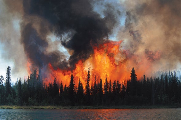
On June 5, 2019, lightning from an unusually early spring thunderstorm ignited a blaze deep inside the Kenai National Wildlife Refuge in south-central Alaska. High temperatures at the end of May had reversed a wet spring and quickly dried out the forest floor. The resulting Swan Lake Fire, about five miles northeast of Sterling, spread relentlessly for a month as the extraordinarily warm weather continued. By July 9 more than 99,000 acres had burned, and more than 400 people were fighting the flames. On August 17 high winds changed the fire's direction, causing numerous evacuations. The wind also downed power lines that sparked new fires, including the Deshka Landing Fire and the fast-moving McKinley Fire, which engulfed more than 130 homes, businesses and outbuildings. Fortunately, no one died.
The Swan Lake Fire burned until October, when overdue rains finally helped firefighters contain the conflagration, after 167,000 acres—261 square miles—had been charred. During the five-month blaze, troopers had to repeatedly close the Sterling Highway, the only major road in the area. Health officials issued public warnings about “unhealthy” or even “hazardous” smoky air filled with tiny particulates that can damage lungs on one third of all days in June, July and August in the south-central region, home to 60 percent of the state's population. Tourism-dependent businesses lost 20 percent of their seasonal revenue.
Winter snow and cold offered a reprieve, but in January 2020 a crew grooming snow machine trails reported smoke where the Deshka Landing Fire had been. When firefighters arrived, they found that the fire had never fully gone out. It had smoldered underground for four months and reemerged through the snow cover. As the state became warm and dry again in June, reports came in of smoke where the Swan Lake Fire had been. It had smoldered through eight months of winter and spring and reignited.
These so-called zombie fires—thought dead but reanimated—are flaring up as climate change makes the Alaska fire season hotter and longer. From 2005 to 2017, fire managers in Alaska and in Canada's Northwest Territories reported 48 zombie, or holdover, fires that survived the long winter. Rebecca Scholten, a remote-sensing specialist at Vrije Universiteit Amsterdam who works with Alaska fire managers, has discovered 20 more that were undocumented, by searching back through satellite imagery. The unusual phenomenon occurs across the high north, and it was responsible for extremely early blazes in northern Siberia in March 2020 and March 2021.
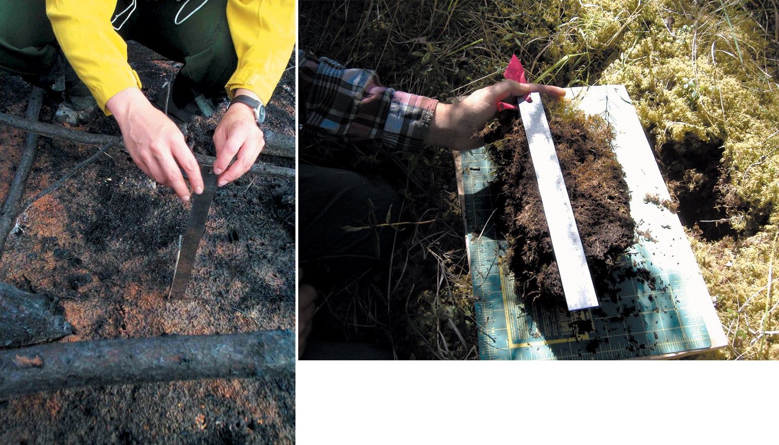
Zombie fires can recur because in northern ecosystems trees are not the only—or even the main—fuel. A thick, organic blanket of live and dead plant material covers the surface in the treeless tundra and the boreal forests just to their south. This dense, peaty layer, called duff, is the accumulation of each summer's dead surface moss and litter, its decomposition slowed by the low temperatures at these high latitudes. Duff can range in thickness from three to 20 inches (eight to 50 centimeters). It can accumulate for centuries, becoming increasingly compacted and dense with time.
The duff's surface is a green veneer made mostly of feather mosses, which do not have roots or a vascular system but instead draw moisture directly from the air. Their moisture content varies almost instantaneously with relative humidity; even after rain, the moss can dry enough within hours to burn. The longer, hotter, drier summers and shorter winters that climate change is bringing to the northern high latitudes are turning wide tracts of forest floor and trees into tinderboxes that lightning—or careless people—can readily ignite.
Wildfires across the high north are increasing in frequency and size. They are also transforming landscapes and ecosystems. In addition to being a fuel, duff is a remarkable insulator of underlying frozen ground—so much so that it has been keeping much of subsurface Alaska frozen since the Pleistocene epoch. Each half-inch of thickness keeps the underlying permafrost—ground that remains below freezing for two or more years—about 1 degree Fahrenheit (0.6 degree Celsius) cooler. But if enough duff burns off, the underlying permafrost thaws, turning parts of Alaska into softening, slumping ground. Trees rooted in this thawing ground can tilt at all angles, like haphazard Leaning Towers of Pisa.
Extensive wildfire is accelerating climate change, too. Large fires throw a stunning amount of carbon dioxide into the atmosphere. Most of it comes from the duff, not the trees. The thick duff layers across high latitudes store 30 to 40 percent of all the soil carbon on Earth. In 2015 severe wildfires in interior Alaska burned 5.1 million acres, releasing about nine million metric tons of carbon from standing vegetation—and 154 million tons from the duff, according to Christopher Potter of NASA's Earth Sciences Division. (That calculation includes carbon lost to decomposition and erosion for two subsequent years.) The total amount of CO2 is equal to that emitted by all of California's cars and trucks in 2017. As more ground thaws, ice in the lower layers of duff melts and drains away, drying the duff farther down, making it more ready to burn deeply. This feedback loop most likely will expand the acres burned, aggravate health for millions of people and make the climate change faster than ever. Feedbacks may even convert the entire region from one that absorbs more carbon than it emits to one that emits more carbon than it absorbs.
Wet yet Dry
People tend to think of Alaska as snowy and unlikely to burn, yet much of the state, especially the interior, has a continental climate with long, cold winters but warm and relatively dry summers. If you fly over interior Alaska in the summer, you will see a vast green landscape of forests, meadows and lakes. The lush appearance is deceiving because the region gets very little precipitation. Slow, sustained melting of snow in spring and thawing of the “active layer” immediately below the duff that refreezes each winter provide water for greening, but the duff surface can become desert-dry with a week or two of warm weather.
Boreal forests are Earth's largest woodland biome, comprising 30 percent of global forest area. They are also the most fire-prone northern ecosystem. Interior Alaska's boreal zone is dominated by black spruce: small, slow-growing trees that form dense stands. Their branches reach all the way down into the duff, providing a ladder for fire. As the dominant conifer in Alaska over the past 7,000 years, black spruce have adapted to the flames; their cones are clustered at the very top of the tree and open after a fire to shed seeds, which help to reestablish the ecosystem.
For decades fire managers in Alaska have monitored ignitions in remote areas and generally allowed them to burn, renewing the fire-dependent ecosystems; much of Alaska, after all, has few settlements or infrastructure to protect. This cost-effective approach has helped Alaska largely avoid the problem, common in the lower 48 states, of forests that are overgrown or have too much deadwood. The approach also means that in Alaska, researchers can see how climate is changing wildfire, without strong effects of human intervention.
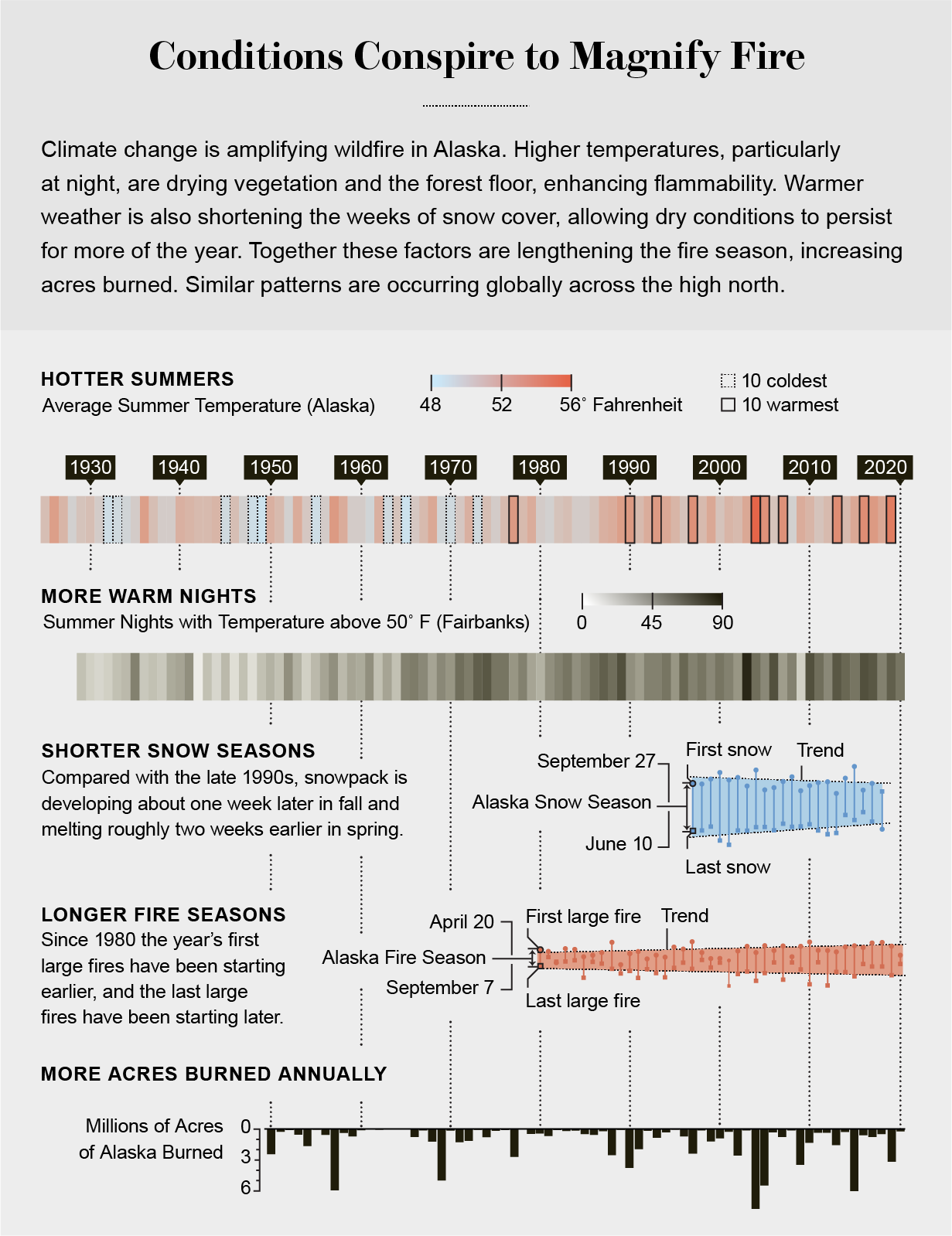
Until recently, fires would typically kill trees but would not penetrate too deeply into the duff, because moisture in the lower layers prevented deeper burning. Severe, deep burns have always happened on occasion during especially hot and dry conditions. In their aftermath, a mosaic of meadows, shrublands and hardwood forests (birch, poplar and aspen) typically emerges, replacing the spruce. Now these extreme events are increasing. In recent years forest fires in Alaska have broken records, burning more acreage, more intensely and for longer. Seasons in which a million or more acres burn are twice as frequent as 30 years ago.
The Arctic-boreal region as a whole is heating up 1.5 to four times faster than temperate zones. Alaska has warmed by four degrees F in the past 50 years, and evidence published in 2021 by David Swanson of the National Park Service Alaska Region suggests that warming has accelerated even more since 2014. This “Arctic amplification” is driven for the most part by disappearing sea and land ice, which leave larger areas of darker ocean and ground cover that absorb much more sunlight than ice or snow.
Winters are warming faster than summers, but the cumulative effect means snowpack is now developing a week later and melting two weeks earlier than in the 1990s, drying out duff for more of the year. Fire season is at least a month longer than it was 30 years ago, putting pressure on agencies to lengthen contracts for firefighters and aircraft. In 2016 Alaska set a record for fire-season length: smokejumpers, who parachute into remote locations, logged the earliest fire jump in their then 57-year history, near Palmer on April 17. And the Alaska Division of Forestry was still fighting flames near Anchorage in early October—in winds so cold they froze the water slopping from helicopter buckets overhead.
Extremely hot days, which are strongly linked to fire growth, are increasing as well. In 2019, the year of the Swan Lake and McKinley Fires, Anchorage set 32 new record highs and experienced 90 degrees F for the first time. According to the latest climate models, the annual number of days above 77 degrees F—a key threshold for drying out burnable vegetation—is expected to double by midcentury Alaska's interior.
More high-latitude fire is happening worldwide. Within the Arctic Circle, 2020 was the record year for wildfires seen by satellite, and 2019 ranks second. In Siberia, estimates indicate that more than 18,000 fires burned 35 million acres in 2020—shocking numbers. Temperature anomalies nearby were remarkable. On June 20 the town of Verkhoyansk, at the same latitude as northern Alaska, hit a record: over 100 degrees F. In the region, precipitation was very low, and snow melt was the earliest since measurements began in 1967. Fire seasons in Russia's Sakha Republic are now two weeks longer than they were a decade ago, and early reports indicate Siberia's 2021 season through July was more extensive than the same period in 2020. In May, Iceland issued the country's first wildfire danger alert. The factors feeding these fires are the same as those in Alaska.
Permafrost and Lightning
Black spruce burn spectacularly, but most of the biomass that goes up in smoke is the duff itself. The forest floor can hold 40 to 100 tons of fuel per acre. The trees themselves add about 30 tons per acre, and even so flames often consume mostly needles and branches, leaving the denser tree trunks standing.
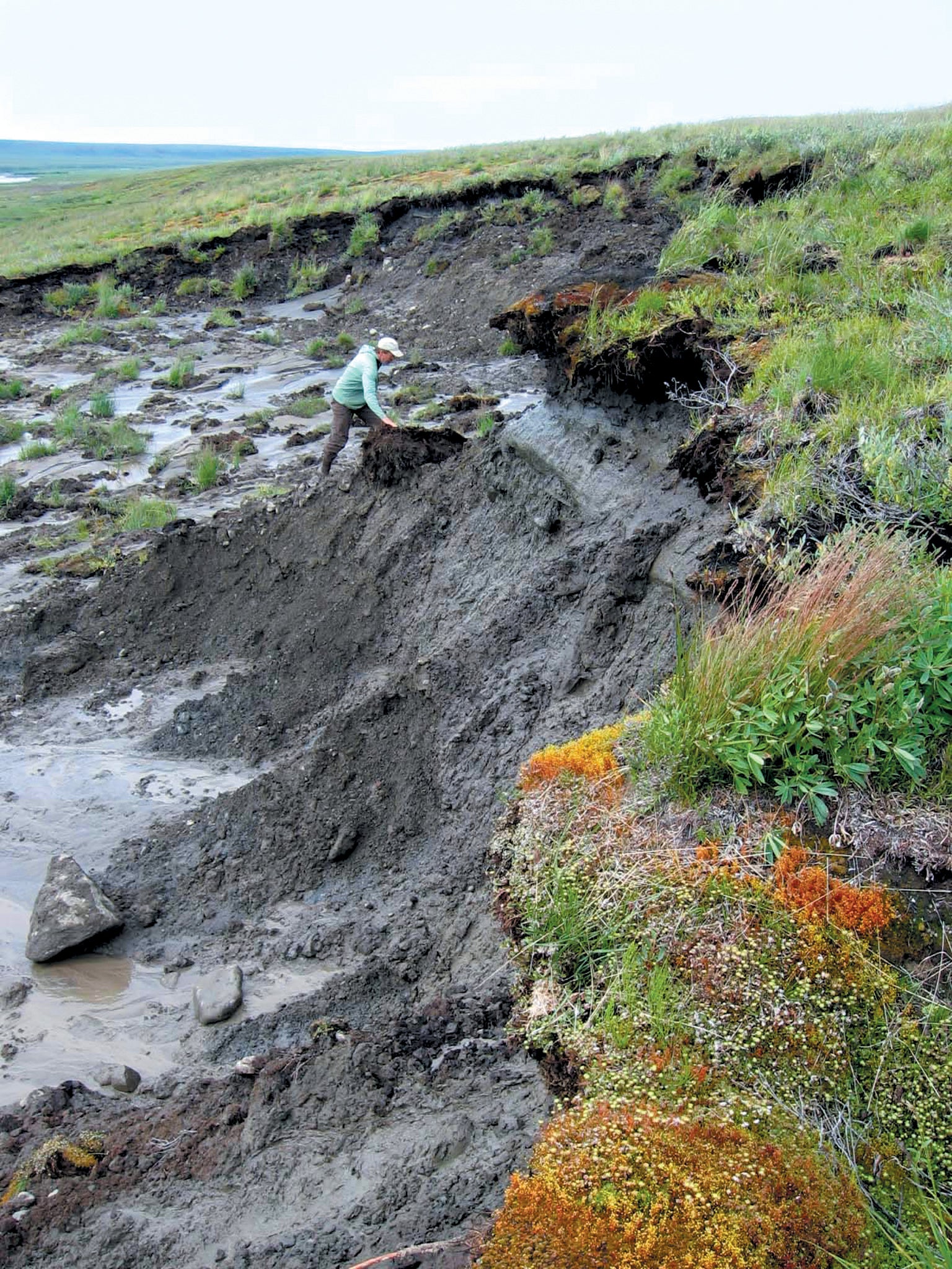
The duff, with its compact but airy layering, is a superb insulator of frozen ground underneath. Permafrost in these regions is widespread and tens of thousands of years old. Alaska is expected to lose 25 percent of its permafrost area by the end of the century just from warming. Fire can accelerate this process. When it leaves less than five inches of insulating duff, the permafrost underneath can thaw and degrade substantially. In Alaska's midlatitudes, fires may trigger enough thaw that the permafrost will never return, barring another Ice Age.
An extreme example of fire-induced thawing was the 2007 Anaktuvuk River Fire (ARF), which burned 250,000 acres of tundra in Alaska's northernmost region, the North Slope, at 70 degrees latitude. Fires beyond the Arctic Circle (67 degrees latitude) are rare; researchers had no record of a blaze this severe so far north. Lightning ignited the ARF in July. Although it appeared to be out by August, it smoldered silently in the duff under the treeless surface and then roared back to life during a warm September. The flames sent thick, billowing smoke over a wide area, choking residents of distant villages. Indigenous hunters said the smoke was disrupting the fall caribou migrations. Extremely dry autumn weather allowed the ARF to burn so deeply into drought-stricken duff that it continued to smolder into October, when lakes were frozen and snow again covered the region. Ultimately more than 400 square miles of continuous permafrost terrain was scarred.
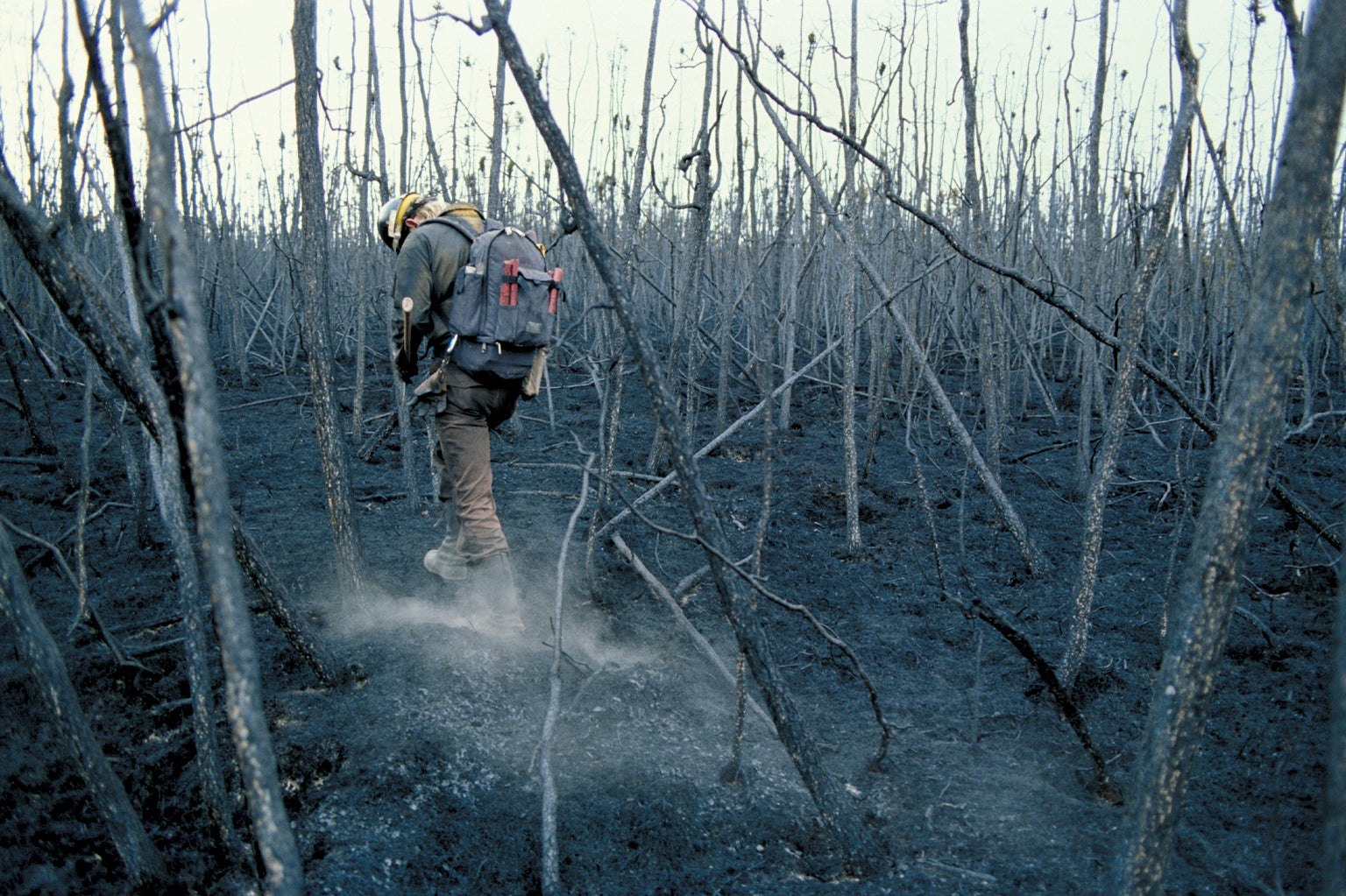
The fire was so extraordinary that one of us (Jandt) initiated a study on behalf of the Bureau of Land Management's Alaska Fire Service into effects on vegetation and the active layer. In early July 2008, the start of the ensuing Arctic summer, the team arrived by helicopter to the ARF. Usually the North Slope at this time of year is cold, windy and drizzly. Instead the helicopter landed on a sea of charred ground under a clear blue sky. The temperature was a staggering 80 degrees F—way too warm for a heavy flight suit and insulated boots. It was so hot and dry that the usual hordes of mosquitoes were gone, replaced by swarms of blackflies.
The survey team saw cumulus clouds building from the warm, rising air masses, which can be fuel for a thunderstorm. Alaskans across interior parts of the state are accustomed to seeing summer heat spawn strong thunderstorms, especially during June and July, when the sun is up for almost 24 hours a day. Fires started by lightning are responsible for 90 percent of the acreage burned in Alaska and Canada's tundra and boreal forests. But lightning on the North Slope had been rare. An Inupiat elder and lifetime resident of Utqiagvik (formerly known as Barrow) said that she had never seen a thunderstorm prior to 1992.
Climate change is increasing lightning activity across the U.S., with the biggest changes at the highest latitudes. A 2014 study by David Romps of the University of California, Berkeley, predicted that each 1.8 degrees F (1 degree C) of warming brings 12 percent more lightning in the contiguous U.S. states. A 2019 analysis by Peter Bieniek of the University of Alaska Fairbanks revealed a 17 percent increase in lightning Alaska-wide over the past 30 years; in some regions, that number is as high as 600 percent. Models by Sander Veraverbeke, a professor of remote sensing at the Vrije Universiteit Amsterdam, predict that by 2050 Alaska will experience 59 percent more lightning, resulting in 78 percent more lightning-ignited wildfires, increasing burned area by 50 percent. A 2021 study found that lightning in the Arctic itself tripled from 2010 to 2020.
Arctic Alaska has experienced the most dramatic warming of any place in the state and, with it, the largest surge in lightning. Mean annual temperatures in Utqiagvik increased 11.4 degrees F from 1976 to 2018, and autumn temperatures have risen 18 degrees F.
Land of Change
The metamorphosis the survey team noted during data gathering from 2008 through 2018 on the North Slope's ARF area parallels changes occurring after severe fires spread across Alaska and across the north. Each time the team was in the burn region it recorded plant cover and pushed metal probes down into the ground along numerous transects to measure the active layer. The thawed soil depth became deeper every year, from four inches greater than the same measurements made outside the burn area one year after the fire to 7.5 inches deeper after four years. Ten years later the active layer showed signs of recovery, possibly stopping the increasing depth of thaw.
Still, these measurements do not convey the magnitude of the surface alterations that took place on the ARF. The entire skin of the earth slid and cracked as the permafrost underneath thawed and the water drained away. Large parcels started to sink, or subside, because the volume of permafrost was disintegrating. From a helicopter, vast portions of the treeless region looked like a checkerboard of earthy squares; the dark, crevasselike channels that outline each of them were deepening significantly. Craters up to 200 feet wide opened where thawing destabilized slopes—a phenomenon called thermokarst mass wasting. Underground ice wedges that had not seen the sun for 60,000 years emerged, smelling like dead dinosaurs.
To chart the changing land, remote-sensing and permafrost experts Ben Jones and Carson Baughman of the U.S. Geological Survey joined the team excursions in 2017. Jones used airborne radar to confirm that surface subsidence was widespread, from four to 40 inches deep. Surface roughness, a measure of subsidence, over much of the eastern half of the burn area increased threefold, giving the landscape deeper channels, taller hummocks and more surface area.
Jones and Baughman left probes in burned and unburned areas that continued to record temperature. Measurements showed that the soil at six inches depth in the burned area averaged 2.7 degrees F warmer on an annual basis, and summer maximum temperatures were 11 degrees F warmer than in the unburned area. Obviously this warming jeopardizes permafrost, but it also influences the plants that will dominate the region. Ten years after the ARF fire, tall shrubs, grasses and other vascular plants, some of which had been rare beforehand, had increased tremendously. In warmer soils, fast-growing grasses and willow shrubs can outcompete the slower-growing mosses, lichens and dwarf shrubs that were prevalent before the fire. These newcomers add more dry litter to the fuel bed every year than the slow-growing mosses do. That may explain why in 2017, a decade after the ARF, there were two new fire scars roughly 100 acres apiece inside the 2007 burn expanse. Repeat fire in just 10 years was unusual inside a burn area where the likely time between subsequent fires has been estimated at several hundred years.
Sink or Source?
Researchers are working hard to understand the consequences of changing fire in the high north. The immediate impacts such as greenhouse gas emissions, poor air quality and infrastructure damage are obvious. Secondary impacts that can arise are challenging to predict. Some are expected, such as soil warming in summer as a result of the charred black surface, undulating landscapes and reestablishment of vegetation as burned plants resprout or reseed. Seasonally thawed soil can deepen; permafrost, if present, can subside. Low-lying areas can become temporarily wetter as ice thaws, helping grasses, shrubs and deciduous trees thrive.
Over time, however, more shrubs across tundra can make the ground even warmer. For one thing, they hold more snow, which insulates the ground from colder air. Burned slopes and ridges can become drier as thaw deepens, allowing even more subsurface drainage; new sensing technology has revealed “taliks”—pockets of unfrozen soil—deep under burned areas, which establish channels of thaw in the permafrost. In boreal forests, changes in habitat and the tree canopy alter patterns of animal movement. And microbes in warmer soils digest more of the ancient carbon in the duff and thawed permafrost, turning it into greenhouse gases, including methane.
More burning across boreal and tundra regions, along with cascading ecosystem changes, has global implications that only large computer models can estimate. The models predict that boreal burning may double or even quadruple by the end of this century, releasing massive quantities of carbon from the ubiquitous duff. That shift could transform the region from a carbon sink to a carbon source, which would amplify climate change worldwide.
It may not be all bad news. Some studies indicate that a shift in forest composition from conifers such as spruce to less flammable deciduous trees such as birch and aspen, as well as a slight increase in rainfall attributed to less sea ice, may offset some of the predicted increase in area burned. If deciduous forests replace conifer forests after fire, they could reflect more sunlight, at least in winter when their leaves are gone and light reflects off the underlying snow, moderating the climate-warming feedback. Warmer tundra soils are already producing more shrubs and ultimately could support trees, which would sequester some of the carbon lost from soils and permafrost in their wood. But the devil is in the details. We need better estimates on each of these factors to predict how feedbacks will unfold.
While scientists work on those tasks, Alaska residents and fire agencies are strategizing about how to protect people, private land, infrastructure and natural resources in an intensifying fire environment. They are improving firefighting preparedness by thinning forest or removing burnable brush and vegetation around towns and cabins. And they are harnessing new technology—such as satellite imagery—for earlier fire detection and for accurate mapping and monitoring. More fire in the high north may alter the land and the climate, but Alaskans are trying to do as much as they can to prevent disastrous loss of life and property.
