The following essay is reprinted with permission from ![]() The Conversation, an online publication covering the latest research.
The Conversation, an online publication covering the latest research.
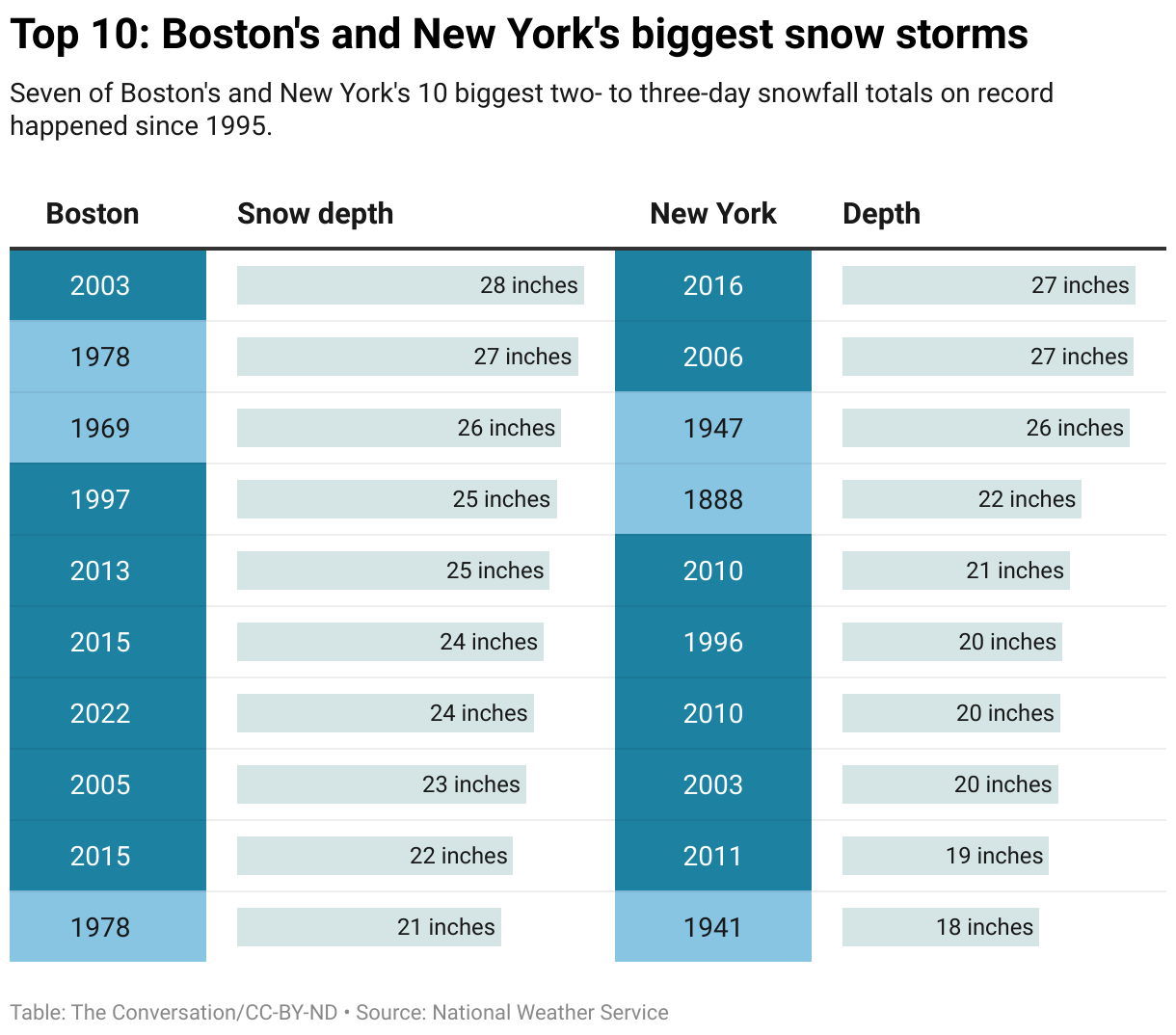
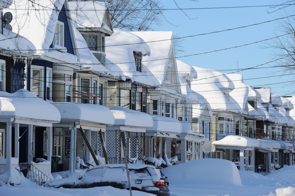
Many of the Northeast’s heaviest snowfalls in over a century of reliable record keeping have occurred since 1990. How can the spate of big snowstorms be reconciled with our warming climate?
I’m an atmospheric scientist. Let’s look at an important law of physics and some theories that can help explain the changes.

Warmer air, more moisture
First, warmer air can hold more moisture than cold air.
Think of the atmosphere like a sponge. Air holds about 4% more water vapor for each additional degree Fahrenheit increase in temperature (that’s about 7% per degree Celsius). The physical law that explains this relationship is known as the Clausius-Clapyron relation.
This increased atmospheric moisture is helping to intensify the water cycle. The Northeast and Mid-Atlantic have become wetter—not just in winter, but in spring, summer and fall, too. In addition to more total precipitation over a season and year, the additional moisture also fuels extreme events, like more intense hurricanes and flooding rains. The Northeast has seen an increase of more than 50% in the heaviest precipitation events in recent decades, the largest increase of any region of the U.S.
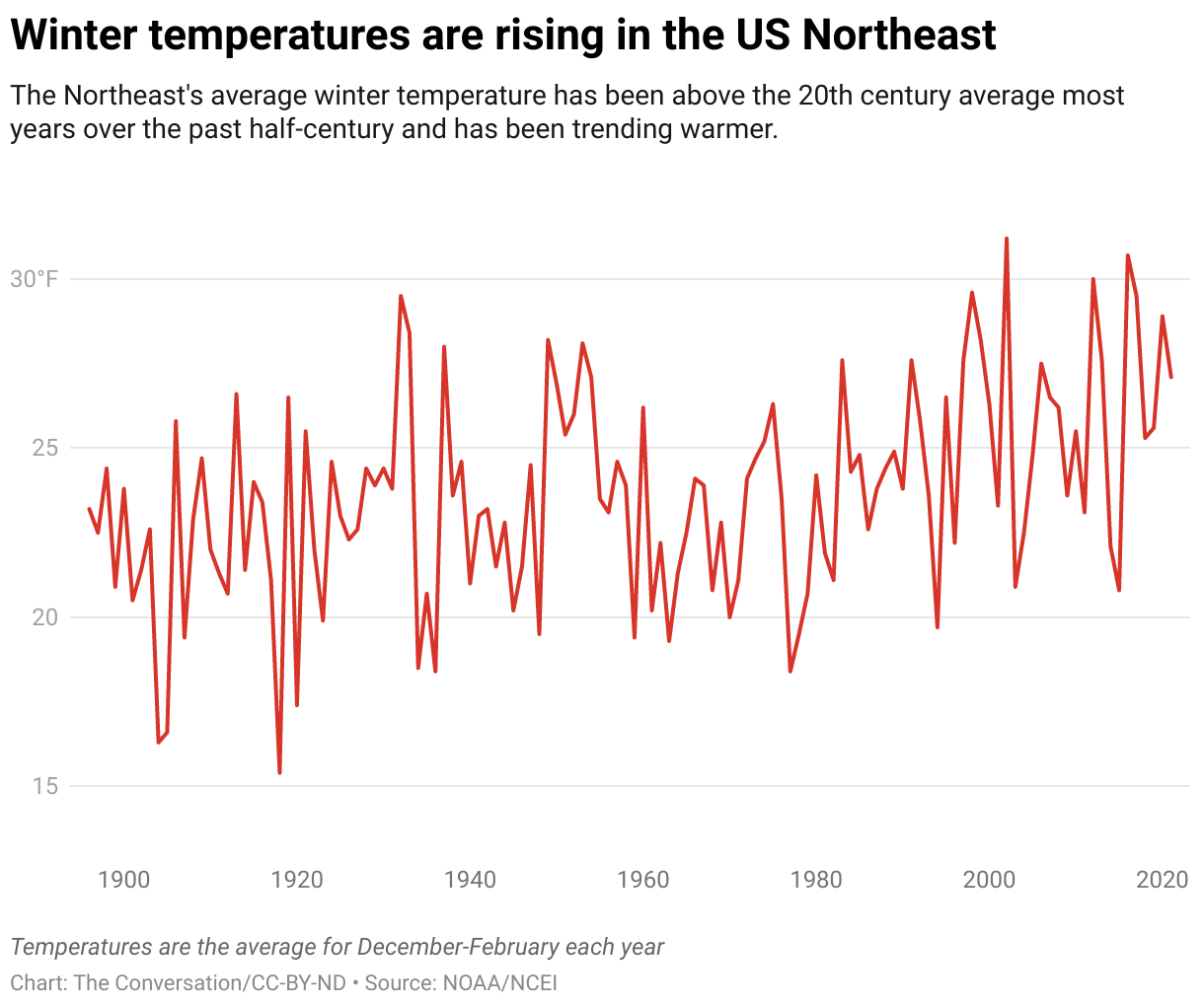
In the early 1900s, winters across the Northeast typically averaged around 22 degrees Fahrenheit. Now, 26 degrees is the official new “normal” temperature, defined as the average over 1991-2020. A few recent winters have been over 30.
In the Northeast, then, we have an environment that has warmed yet is often still below freezing. Put another way, regions of the world that are cold enough for snow have warmed enough to now be visited by storms capable of holding and dropping more moisture. Rather than intense downpours, the region gets heavy snow.
The warming ocean plays a role
The historic blizzard that buried Boston under nearly 2 feet of snow in January 2022 was fueled by ocean waters in the western Atlantic that are warmer than normal. That’s also part of a consistent pattern.

The oceans have been absorbing more than 90% of the additional heat attributable to rising atmospheric greenhouse gases from human activities, particularly burning fossil fuels. The oceans now contain more heat energy than any time since measurements began six decades ago.
Scientists are studying whether global warming may be driving a slowing of the ocean conveyor belt of currents that transport water around the globe. Satellite imagery and ocean measurements show that warmer waters have “piled up” along the East Coast, a possible indication of a slowing of the Atlantic Meridional Overturning Circulation.
Moisture evaporated from ocean water provides much of the energy for both tropical and mid-latitude extra-tropical cyclones, known commonly as nor’easters.
The Arctic influences the snow pattern, too
While tropical storm systems are fueled primarily by warm water, nor’easters gain energy from sharp temperature gradients where cold and warm air masses meet. The frequency of cold air outbreaks is another aspect of climate change that may be contributing to recent increases in extreme snowfall events.
Recent research has suggested that a warming Arctic, including declines in Arctic sea ice and snow cover, is influencing behavior of the polar vortex, a band of strong westerly winds that forms in the stratosphere between about 10 and 30 miles above the Arctic every winter. The winds enclose a large pool of extremely cold air.
When the Arctic is relatively warm, the polar vortex tends to be weaker and more easily elongates or “stretches,” allowing extremely cold air to dip south. Episodes of polar-vortex stretching have markedly increased in the past few decades, leading, at times, to more severe winter weather in some places.
Arctic amplification, the enhanced warming to our north, may, paradoxically, be helping to shuttle cold air to the Eastern Seaboard during polar vortex disruptions, where the cold air can interact with warmer, moisture-laden air from the warmer-than-normal western Atlantic Ocean. The most recent stretched polar vortex event helped to bring together key ingredients for the historic blizzard.
What’s ahead?
Global climate models project an increase in the most extreme snowfall events across large areas of the Northern Hemisphere with future warming. In some other parts of the world, like Western Europe, intensification of the hydrological cycle will mean more winter rain than snow as temperatures rise.
For the east coast of North America, as well as Northern Asia, winter temperatures are expected to still be cold enough for storms to bring heavy snow—at least through mid-century. Climate models suggest that extreme snowfalls will become rarer, but not necessarily less intense, in the second half of the century, as more storms produce rain.
The sharp increase in high-impact Northeast winter storms is an expected manifestation of a warming climate. It’s another risk the U.S. will have to prepare for as extreme events become more common with climate change.
This article was originally published on The Conversation. Read the original article.


